| Brown Mountain | |
|---|---|
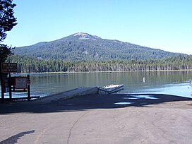
 Brown Mountain from across Lake of the Woods | |
| Highest point | |
| Elevation | 7344+ ft (2238+ m) NAVD 88[1] |
| Prominence | 2,058 ft (627 m)[1] |
| Coordinates | 42°21′48″N 122°16′17″W / 42.36333°N 122.27139°W[2] |
| Geography | |
| Location | Klamath / Jackson counties, Oregon, U.S. |
| Topo map | USGS Brown Mountain |
| Geology | |
| Mountain type | Shield volcano[3] |
| Volcanic arc | Cascade Volcanic Arc[3] |
| Last eruption | Over 12,000 years ago[3] |
| Climbing | |
| Easiest route | Scramble[4] |
Brown Mountain is a small cinder cone on top of a shield volcano located in Cascade Volcanic Arc in Klamath and Jackson counties, Oregon.[3] Most of the mountain, including its peak, is in western Klamath County, but its western flanks trail off into eastern Jackson County. It is 7,344 feet (2,238 m) above sea level, but is overshadowed by nearby 9,495-foot (2,894 m) Mount McLoughlin.[5]
- ^ a b "Brown Mountain, Oregon". peakbagger.com. Retrieved 2021-12-03.
- ^ "Brown Mountain". Geographic Names Information System. United States Geological Survey, United States Department of the Interior. Retrieved 2008-11-22.
- ^ a b c d "Oregon Volcanoes - Brown Mountain Volcano". Deschutes & Ochoco National Forests - Crooked River National Grassland. United States Forest Service. 2006-11-23. Archived from the original on 2010-11-09. Retrieved 2008-09-08.
- ^ Wood, Charles A.; Jűrgen Kienle (1993). Volcanoes of North America. Cambridge University Press. p. 199. ISBN 0-521-43811-X.
- ^ "Description: Brown Mountain, Oregon". United States Geological Survey. 2000-08-21. Archived from the original on 2008-07-04. Retrieved 2009-03-17.
