Browns Valley | |
|---|---|
 Browns Valley Carnegie Library | |
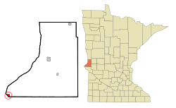
 Location of Browns Valley within Traverse County, Minnesota | |
| Coordinates: 45°35′41″N 96°49′54″W / 45.59472°N 96.83167°W | |
| Country | United States |
| State | Minnesota |
| County | Traverse |
| Area | |
| • Total | 0.78 sq mi (2.02 km2) |
| • Land | 0.78 sq mi (2.02 km2) |
| • Water | 0.00 sq mi (0.00 km2) |
| Elevation | 988 ft (301 m) |
| Population | |
| • Total | 558 |
| • Estimate (2021)[3] | 546 |
| • Density | 714.47/sq mi (275.87/km2) |
| Time zone | UTC-6 (CST) |
| • Summer (DST) | UTC-5 (CDT) |
| ZIP code | 56219 |
| Area code | 320 |
| FIPS code | 27-08200[4] |
| GNIS feature ID | 0659752[5] |
| Website | brownsvalleymn.com |
Browns Valley is a city in Traverse County, Minnesota, United States, adjacent to the South Dakota border. The population was 558 at the 2020 census.[2]
Browns Valley lies along the Little Minnesota River between the northern end of Big Stone Lake and the southern end of Lake Traverse, which is separated from the Little Minnesota River by a low and narrow continental divide that skirts the northern edge of town. The city, both lakes, and the river lie in the Traverse Gap, the bed of ancient, south-flowing Glacial River Warren, the outlet to Glacial Lake Agassiz which, when drained, became the valley of the north-flowing Red River of the North.
- ^ "2020 U.S. Gazetteer Files". United States Census Bureau. Retrieved July 24, 2022.
- ^ a b "Explore Census Data". United States Census Bureau. Retrieved May 1, 2022.
- ^ Cite error: The named reference
USCensusEst2021was invoked but never defined (see the help page). - ^ "U.S. Census website". United States Census Bureau. Retrieved January 31, 2008.
- ^ "US Board on Geographic Names". United States Geological Survey. October 25, 2007. Retrieved January 31, 2008.