Bude
| |
|---|---|
 | |
Location within Cornwall | |
| Population | 9,222 (2011 census)[1][2] |
| OS grid reference | SS215065 |
| Civil parish | |
| Unitary authority | |
| Ceremonial county | |
| Region | |
| Country | England |
| Sovereign state | United Kingdom |
| Post town | BUDE |
| Postcode district | EX23 |
| Dialling code | 01288 |
| Police | Devon and Cornwall |
| Fire | Cornwall |
| Ambulance | South Western |
| UK Parliament | |
| Website | www.visitbude.info www.bude-stratton.gov.uk/ |
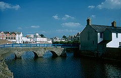
Bude (/bjuːd/; Standard Written Form: Porthbud)[3] is a seaside town in north Cornwall, England, United Kingdom, in the civil parish of Bude-Stratton and at the mouth of the River Neet (also known locally as the River Strat). It was sometimes formerly known as Bude Haven.[4] It lies southwest of Stratton, south of Flexbury and Poughill, and north of Widemouth Bay, located along the A3073 road off the A39. Bude is twinned with Ergué-Gabéric in Brittany, France.[5] Bude's coast faces Bude Bay in the Celtic Sea, part of the Atlantic Ocean. The population of the civil parish can be found under Bude-Stratton.
Its earlier importance was as a harbour, and then a source of sea sand useful for improving the inland soil. This was transported on the Bude Canal. The Victorians favoured it as a seaside resort. With new rail links, it became a popular seaside destination in the 20th century. Bradshaw's Guide of 1866, Section 2, described Bude as: "a small port and picturesque village in the north-eastern extremity of Cornwall". It described the town as having the dignity of a fashionable marine resort with excellent facilities for bathers. The harbour bed consists of fine bright yellow sand consisting of small shells. "The sea view is of a striking, bold and sublime description – the rocks rising on every side to lofty broken elevations". It also describes Bude as a romantic retreat.
- ^ Bude North and Stratton ward http://ukcensusdata.com/bude-north-and-stratton-e05008204#sthash.FX70Swfa.dpbs
- ^ Bude South http://ukcensusdata.com/bude-south-e05008205#sthash.bCnKcha1.dpbs
- ^ "List of Place-names agreed by the MAGA Signage Panel" (PDF). Cornish Language Partnership. May 2014. Archived from the original (PDF) on 29 July 2014. Retrieved 11 January 2015.
- ^ Cornish Church Guide (1925) Truro: Blackford; p. 66
- ^ "Bude Is Twinned With ERGUE- GABERIC....a taster..." Bude People. 10 May 2011. Archived from the original on 11 January 2015. Retrieved 22 July 2012.
