Bukit Timah | |
|---|---|
| Other transcription(s) | |
| • Malay | Bukit Timah (Rumi) بوکيت تيمه (Jawi) |
| • Chinese | 武吉知马 (Simplified) 武吉知馬 (Traditional) Wǔjí Zhīmǎ (Pinyin) Bú-kit Ti-má (Hokkien POJ) |
| • Tamil | புக்கிட் திமா Pukkiṭ timā (Transliteration) |
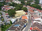
From top left to right: National Junior College, Ngee Ann Polytechnic, The Chinese High School Clock Tower Building, Aerial view of the Bukit Timah portion of Holland Village, former Bukit Timah railway station | |
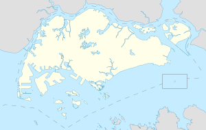
 Location of Bukit Timah in Singapore | |
 Location in Central Region | |
| Coordinates: 1°19′45.88″N 103°48′7.48″E / 1.3294111°N 103.8020778°E | |
| Country | |
| Region | Central Region
|
| CDCs | |
| Town councils |
|
| Constituencies | |
| Government | |
| • Mayors | Central Singapore CDC
North West CDC South West CDC |
| • Members of Parliament | Bishan-Toa Payoh GRC
Holland-Bukit Timah GRC Jurong GRC Tanjong Pagar GRC |
| Area | |
| • Total | 17.53 km2 (6.77 sq mi) |
| Population | |
| • Total | 77,860 |
| • Density | 4,400/km2 (12,000/sq mi) |
| Ethnic groups | |
| • Chinese | 67,400 |
| • Malays | 640 |
| • Indians | 3,840 |
| • Others | 5,980 |
| Postal districts | 10, 11, 21 |
| Dwelling units | 2,423 |
Bukit Timah /ˈbʊkɪt ˌtiːmɑː/, often abbreviated as Bt Timah, is a planning area and residential estate located in the westernmost part of the Central Region of Singapore. Bukit Timah lies roughly 10 kilometres (6.2 mi) from the Central Business District, bordering the Central Water Catchment to the north, Bukit Panjang to the northwest, Queenstown to the south, Tanglin to the southeast, Clementi to the southwest, Novena to the east and Bukit Batok to the west.
Owing to its prime location, Bukit Timah has some of the densest clusters of luxury condominiums and landed property in the city, with very few public housing.
- ^ a b City Population - statistics, maps and charts | Bukit Timah
- ^ HDB Key Statistics FY 2014/2015 Archived 4 March 2016 at the Wayback Machine
- ^ a b "Statistics Singapore - Geographic Distribution - 2018 Latest Data". Retrieved 11 February 2019.


