Burhanpur
| |
|---|---|
City | |
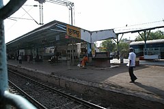
From top, left to right: Shahi Qila, Asirgarh Fort, Jama Masjid, Dargaah-e-Hakimi, Burhanpur railway station | |
| Coordinates: 21°18′41″N 76°13′44″E / 21.31139°N 76.22889°E | |
| Country | |
| State | Madhya Pradesh |
| District | Burhanpur |
| Founded | 1380 |
| Named for | Burhanuddin Gharib |
| Government | |
| • Mayor | Smt. Madhuri Atul Patel (BJP)[2] |
| Area | |
| • Total | 34.6 km2 (13.4 sq mi) |
| Elevation | 247 m (810 ft) |
| Population (2011)[3] | |
| • Total | 210,891 |
| • Density | 6,100/km2 (16,000/sq mi) |
| Languages | |
| • Official | Hindi[4] |
| Time zone | UTC+5:30 (IST) |
| PIN | 450331 |
| Telephone code | (+91) 7325 |
| ISO 3166 code | IN-MP |
| Vehicle registration | MP-68 |
| Website | burhanpur |
Burhanpur is a historical city in the Indian state of Madhya Pradesh. It is the administrative seat of Burhanpur District. It is situated on the north bank of the Tapti River and 512 kilometres (318 mi) northeast of city of Mumbai , 340 kilometres (211 mi) southwest of the state's capital city of Bhopal. The city is a Municipal Corporation.
- ^ Mundy, Peter; Temple, Richard Carnac; Anstey, Lavinia Mary (1907). The travels of Peter Mundy in Europe and Asia, 1608-1667. Cambridge [Eng] Printed for the Hakluyt Society. ISBN 978-0-8115-0338-9.
- ^ "MP Civic Polls Result: बुरहानपुर में BJP की मेयर प्रत्याशी माधुरी पटेल की जीत, चौथी बार नगर निगम पर बीजेपी का कब्जा". TV9 Bharatvarsh (in Hindi). 17 July 2022. Retrieved 20 July 2022.
- ^ Cite error: The named reference
Census2011Govwas invoked but never defined (see the help page). - ^ "52nd Report of the Commissioner for Linguistic Minorities in India" (PDF). Nclm.nic.in. Ministry of Minority Affairs. p. 45. Archived from the original (PDF) on 25 May 2017. Retrieved 30 August 2019.


