| Burketown Queensland | |||||||||||||||
|---|---|---|---|---|---|---|---|---|---|---|---|---|---|---|---|
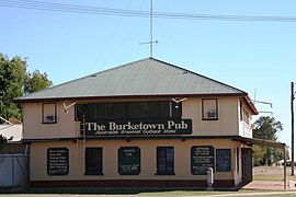
 Burketown pub (since destroyed) | |||||||||||||||
| Coordinates | 17°44′27″S 139°32′52″E / 17.7408°S 139.5477°E | ||||||||||||||
| Population | 204 (2021 census)[1] | ||||||||||||||
| • Density | 0.11907/km2 (0.3084/sq mi) | ||||||||||||||
| Established | 1865 | ||||||||||||||
| Postcode(s) | 4830 | ||||||||||||||
| Elevation | 6 m (20 ft)[2] | ||||||||||||||
| Area | 1,713.3 km2 (661.5 sq mi) | ||||||||||||||
| Time zone | AEST (UTC+10:00) | ||||||||||||||
| Location |
| ||||||||||||||
| LGA(s) | Shire of Burke | ||||||||||||||
| State electorate(s) | Traeger | ||||||||||||||
| Federal division(s) | Kennedy | ||||||||||||||
| |||||||||||||||
| |||||||||||||||
Burketown is an isolated outback town and coastal locality in the Shire of Burke, Queensland, Australia.[3][4] In the 2021 census, the locality of Burketown had a population of 204 people.[1]
It is located 898 kilometres or 558 miles west of Cairns and 227 kilometres or 141 miles west of Normanton on the Albert River and Savannah Way in the area known as the Gulf Savannah.[5]
- ^ a b Cite error: The named reference
Census2021was invoked but never defined (see the help page). - ^ "BURKETOWN POST OFFICE". Bureau of Meteorology. Archived from the original on 30 June 2009. Retrieved 13 September 2009.
- ^ "Burketown – town in Shire of Burke (entry 5355)". Queensland Place Names. Queensland Government. Retrieved 26 December 2020.
- ^ "Burketown – locality in Shire of Burke (entry 42539)". Queensland Place Names. Queensland Government. Retrieved 26 December 2020.
- ^ "Gulf Savannah Development 2007". Gulf Savannah Development. Archived from the original on 11 February 2008. Retrieved 31 December 2007.
