Burnett Highway | |
|---|---|
 | |
| Burnett Highway (green on black) | |
| General information | |
| Type | Highway |
| Length | 542 km (337 mi) |
| Route number(s) |
|
| Former route number | |
| Major junctions | |
| North end | |
| |
| South end | |
| Location(s) | |
| Major settlements | Mt. Morgan, Dululu, Biloela, Monto, Eidsvold, Mundubbera, Gayndah, Ban Ban Springs, Goomeri |
| Highway system | |
| ---- | |
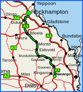
The Burnett Highway is an inland rural highway located in Queensland, Australia. The highway runs from its junction with the Bruce Highway at Gracemere, just south of Rockhampton, to the D'Aguilar Highway in Nanango. Its length is approximately 542 kilometres. The highway takes its name from the Burnett River, which it crosses in Gayndah. The Burnett Highway provides the most direct link between the northern end of the New England Highway (at Yarraman, 21 kilometres (13 mi) south of Nanango) and Rockhampton. It is designated as a State Strategic Road (part of Australia’s Country Way) by the Queensland Government.[1]
- ^ "Queensland Government - Department of Transport and Main Roads - Maps". Archived from the original on 19 March 2018. Retrieved 20 April 2014.