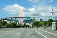
 Facing west on the Burnside Bridge | |
| Former name(s) |
|
|---|---|
| Owner | Portland Bureau of Transportation west of the east 16100 block; City of Gresham east of east 16100 to Mt. Hood Hwy |
| Length | 17.6 mi (28.3 km)[1] |
| Location | Portland and Gresham, Oregon, U.S. |
| From | Mount Hood Highway |
| To | SW Barnes Road |
Burnside Street is a major thoroughfare of Portland, in the U.S. state of Oregon, and one of a few east–west streets that runs uninterrupted on both sides of the Willamette River. It serves as the dividing line between North Portland and South Portland. Its namesake bridge, Burnside Bridge, is one of the most heavily traversed in Portland. In Gresham between approximately the east 18300 block to Mt. Hood Hwy (and E Powell Blvd/SE Powell Valley Rd), Burnside runs southeast–northwest and is no longer the divide between northeast and southeast on the City of Portland-Multnomah County street grid. Additionally (as you travel southeast), SE Burnside St becomes NW Burnside Road at SE 202nd/NW Birdsdale Ave, and NE Burnside Rd at N Main Ave in Gresham. Burnside Road's eastern terminus is where it meets Mt. Hood Hwy (US-26), E Powell Blvd (US-26), and SE Powell Valley Road.
- ^ "Burnside Road". Google Maps. Retrieved January 22, 2016.