Buru Regency
Kabupaten Buru | |
|---|---|
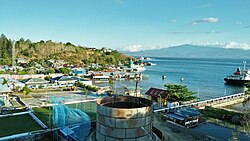
 Coastal area of Buru Island | |
| Motto(s): Retemena Barasehe (Keep Moving Forward, Never Give Up) | |
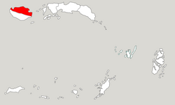
 Location within Maluku | |
| Coordinates: 3°19′40″S 126°41′03″E / 3.3277°S 126.6841°E | |
| Country | |
| Province | |
| Capital | Namlea |
| Government | |
| • Regent | Ramly I. Umasugi |
| • Vice Regent | Amustofa Besan |
| Area | |
| • Total | 7,595.58 km2 (2,932.67 sq mi) |
| Population (mid 2023 estimate)[1] | |
| • Total | 139,408 |
| • Density | 18/km2 (48/sq mi) |
| Time zone | UTC+9 (IEST) |
| Area code | (+62) 913 |
| Website | burukab |
Buru Regency is a regency of Maluku province, Indonesia. When it was first created on 4 October 1999 (by separation from Central Maluku Regency), the regency encompassed the entire island (plus outlying islands); but on 24 June 2008 the southern 40% of the island was split off to form a separate Buru Selatan (South Buru) Regency. The residual Buru Regency comprises the northern 60% of the island of Buru and covers an area of 7,595.58 km2. The population at the 2010 census was 108,445[2] and at the 2020 census this had increased to 135,238;[3] the official estimate as at mid 2023 was 139,408 (comprising 70,598 males and 68,810 females).[1] The principal town lies at Namlea.


