Buttonwillow | |
|---|---|
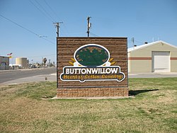
 The entrance to Buttonwillow | |
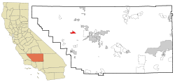
 Location in Kern County and the state of California | |
| Coordinates: 35°24′02″N 119°28′10″W / 35.40056°N 119.46944°W | |
| Country | |
| State | |
| County | Kern |
| Government | |
| • Senate | Melissa Hurtado (D) |
| • Assembly | Rudy Salas (D) |
| • U. S. Congress | David Valadao (R) |
| Area | |
| • Total | 6.93 sq mi (17.94 km2) |
| • Land | 6.93 sq mi (17.94 km2) |
| • Water | 0.00 sq mi (0.00 km2) 0% |
| Elevation | 269 ft (82 m) |
| Population (2020) | |
| • Total | 1,337 |
| • Density | 193.01/sq mi (74.52/km2) |
| Time zone | UTC-8 (PST) |
| • Summer (DST) | UTC-7 (PDT) |
| ZIP code | 93206 |
| Area code | 661 |
| FIPS code | 06-09332 |
| GNIS feature ID | 1652678 |
Buttonwillow[3] is an unincorporated community and census-designated place in the San Joaquin Valley, in Kern County, California. Buttonwillow is 26 miles (42 km) west of Bakersfield,[3] at an elevation of 269 feet (82 m)).[2] The population was 1,508 at the 2010 census, up from 1,266 at the 2000 census. The center of population of California is located in Buttonwillow.[note 1]
- ^ "2020 U.S. Gazetteer Files". United States Census Bureau. Retrieved October 30, 2021.
- ^ a b U.S. Geological Survey Geographic Names Information System: Buttonwillow, California
- ^ a b Durham, David L. (1998). California's Geographic Names: A Gazetteer of Historic and Modern Names of the State. Clovis, Calif.: Word Dancer Press. p. 1009. ISBN 1-884995-14-4.
- ^ "Population and Population Centers by State: 2000". United States Census 2000. US Census Bureau Geography Division. May 20, 2002. Archived from the original (TXT) on May 8, 2013. Retrieved December 26, 2009.
Cite error: There are <ref group=note> tags on this page, but the references will not show without a {{reflist|group=note}} template (see the help page).
