Byndoor
Coastal Town | |
|---|---|
Town | |
 | |
| Coordinates: 13°51′58″N 74°38′00″E / 13.866°N 74.6333°E | |
| Country | |
| State | Karnataka |
| District | Udupi |
| Named for | Bindu Pura |
| Government | |
| • Body | Byndoor Town Panchayat |
| Area | |
• Total | 67.0536 km2 (25.8895 sq mi) |
| Elevation | 10 m (30 ft) |
| Population (2011) | |
• Total | 24,957 |
| • Density | 370/km2 (960/sq mi) |
| Languages | |
| • Official | Kannada |
| Time zone | UTC+5:30 (IST) |
| PIN | 576214 |
| Telephone code | +91-8254 |
| ISO 3166 code | IN-KA |
| Vehicle registration | KA-20 |
| Sex ratio | 1.04 ♂/♀ |
| Literacy | 87% |
| Distance from Bangalore | 480 kilometres (300 mi) NW |
| Distance from Udupi | 60 kilometres (37 mi) E |
| Climate | Tropical savanna climate (Köppen) |
| Precipitation | 950 millimetres (37 in) |
| Avg. summer temperature | 31 °C (88 °F) |
| Avg. winter temperature | 25 °C (77 °F) |
| Website | baindurutown |
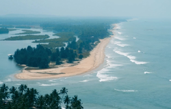
Byndoor is a coastal town and headquarters of Byndoor Taluk in the Udupi District of Karnataka state, India. It is about 450 kilometres (280 mi) from the state capital Bengaluru and 60 kilometres (37 mi) from the Udupi district headquarters. It has an area of 67.0536 square kilometres (25.8895 sq mi) and a population of 24,957 in 2011.[1] It lies in the foothills of Western Ghats on one side and a virgin Someshwar Beach on the other side. The Mookambika Road Byndoor railway station focuses on the pilgrims visiting the Kollur Mookambika Temple which is 28 km from Byndoor. Near by another railway station name is Bijoor, As many as 26 villages including Shiroor, Paduvari, Yadthare, Taggarse, Uppunda, Nandanavana, Kergalu, (Naikanakatte) Bijoor, Kirimanjeshwar, Ullur, Khambadakone, Heranjalu, Navunda, Badakere, Maravanthe, Hadavu, Naada, herur, Kalthodu, Golihole, Yalajith, Kollur, Jadkal, Mudoor, and Hallihole have been brought together under the Byndoor taluk.
- ^ "Karnataka Census". Archived from the original on 1 February 2014. Retrieved 2014-01-28.
