Cabedelo | |
|---|---|
Municipality | |
| Município de Cabedelo | |
 Areia Vermelha | |
| Motto: VRBS NESCIA VINCI | |
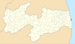
 Location of Cabedelo in the state of Paraíba | |
| Coordinates: 06°58′51″S 34°50′02″W / 6.98083°S 34.83389°W | |
| Country | |
| Region | Northeast |
| State | |
| Government | |
| • Prefeito | Vitor Hugo (DEM) |
| Area | |
| • Total | 31.915 km2 (12.322 sq mi) |
| Elevation | 3 m (10 ft) |
| Population (2020 [1]) | |
| • Total | 68,767 |
| Time zone | UTC−3 (BRT) |
| Website | [1] |
Cabedelo is a municipality of the Metropolitan Region of João Pessoa, in the state of Paraíba in the Northeast Region of Brazil.[2][3][4][5]
It has an area of 29,873 square kilometers, with singular measures: 18 kilometers long and only three kilometers wide. Its population in 2020 was estimated by the Brazilian Institute of Geography and Statistics (IBGE) at 68,767 inhabitants. On 17th century Dutch maps, it appeared as an island because of the Jaguaribe and Mandacaru rivers. Its geophysical age also differs from neighbouring municipalities that tend to have older sedimentary plateaus and therefore divergent average altitude and climate.
Currently, it is troubled by the capital of Paraíba, João Pessoa, and serves as an extension of certain tertiary activities of the headquarters, such as tourism but also private higher education, etc. CBTU urban trains and Estrada de Cabedelo (BR-230) are the main connections between the two cities. It is the richest municipality in the state in terms of gross domestic product per capita, as it has a gross domestic product of more than 2.2 billion reais according to updated data from 2007, that is, more than half of the economy of Campina Grande (another large city in the state) in a much smaller area and with a much lower population. It has one of the largest proportional gross domestic products in the Northeast, comparable to cities like Ipojuca and Guamaré.
The municipality contains the 103 hectares (250 acres) Restinga de Cabedelo National Forest, created in 2004.[6]
- ^ IBGE 2020
- ^ "Divisão Territorial do Brasil" (in Portuguese). Divisão Territorial do Brasil e Limites Territoriais, Instituto Brasileiro de Geografia e Estatística (IBGE). July 1, 2008. Retrieved December 17, 2009.
- ^ "Estimativas da população para 1º de julho de 2009" (PDF) (in Portuguese). Estimativas de População, Instituto Brasileiro de Geografia e Estatística (IBGE). August 14, 2009. Retrieved December 17, 2009.
- ^ "Ranking decrescente do IDH-M dos municípios do Brasil" (in Portuguese). Atlas do Desenvolvimento Humano, Programa das Nações Unidas para o Desenvolvimento (PNUD). 2000. Archived from the original on October 3, 2009. Retrieved December 17, 2009.
- ^ "Produto Interno Bruto dos Municípios 2002-2005" (PDF) (in Portuguese). Instituto Brasileiro de Geografia e Estatística (IBGE). December 19, 2007. Archived from the original (PDF) on October 2, 2008. Retrieved December 17, 2009.
- ^ FLONA da Restinga de Cabedelo (in Portuguese), ISA: Instituto Socioambiental, retrieved 2017-03-22


