49°07′35″N 123°49′40″W / 49.1264°N 123.8277°W
| Cable Bay Trail | |
|---|---|
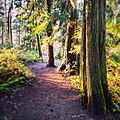
 Trail through the upper forest | |
| Length | 2 km (1.2 mi) |
| Location | Cedar, British Columbia |
| Trailheads | Nicola Road |
| Use | Hiking |
| Elevation gain/loss | 90m |
| Highest point | 90m |
| Lowest point | 0m |
| Difficulty | Easy |
| Sights | Beaches, old growth forest, birds and marine mammals |
| Hazards | Moderately steep section of trail and slippery rocks |
The Cable Bay Trail is a 2 km hiking trail located on Vancouver Island, British Columbia, Canada. The trail has been ranked among the top ten forest walks in the Vancouver Island Region.[1]
The trail is accessed via Nicola Road in Cedar. The trail winds down to the oceanfront overlooking Gabriola Island through a coastal Douglas Fir forest, which leads down Joan Point Park, a 23-acre waterfront park which provides a vantage point overlooking Dodds Narrows. Dodds Narrows is a narrow tidal passage separating Vancouver Island from Mudge Island, which flows in opposing directions based on tidal flows. The narrows is a hot spot for marine activity and a popular marine passage between Nanaimo and the Southern Gulf Islands. Passage through Dodds Narrows is described in detail in Margaret Sharcott's 1957 book, Troller's Holiday.[2]
The trail also passes through Garry Oak ecosystems, and features in genetic studies of endangered Garry Oak populations.[3]
-
 The Cable Bay Trail leading down through the forest
 -
 The trail leading through the woods

- ^ "Cathedral Grove Ranked Top Forest Walk In Vancouver Island Region". HuffPost Canada. 2013-09-03. Retrieved 2018-11-16.
- ^ Pagh, Nancy (1999). "An Indescribable Sea: Discourse of Women Traveling the Northwest Coast by Boat". Frontiers: A Journal of Women Studies. 20 (3): 1–26. doi:10.2307/3347216. JSTOR 3347216.
- ^ E., Catherall, Erin; K., Janes, Jasmine; A., Josefsson, Caroline; C., Gorrell, Jamieson (2018). "[Pre-print] Spatial and temporal assessments of genetic structure in an endangered Garry oak ecosystem on Vancouver Island". Botanique. doi:10.25316/ir-409. ISSN 1916-2790.
{{cite journal}}: CS1 maint: multiple names: authors list (link)