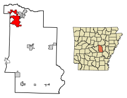
Cabot, Arkansas | |
|---|---|
 Location in Lonoke County, Arkansas | |
| Coordinates: 34°58′22″N 92°1′20″W / 34.97278°N 92.02222°W | |
| Country | United States |
| State | Arkansas |
| County | Lonoke |
| Founded | 1873 |
| Incorporated | 1891 |
| Area | |
| • City | 20.78 sq mi (53.82 km2) |
| • Land | 20.68 sq mi (53.57 km2) |
| • Water | 0.10 sq mi (0.25 km2) |
| Elevation | 299 ft (91 m) |
| Population (2020) | |
| • City | 26,569 |
| • Density | 1,284.58/sq mi (495.99/km2) |
| • Metro | 685,488 (Little Rock) |
| Time zone | UTC-6 (CST) |
| • Summer (DST) | UTC-5 (CDT) |
| ZIP code | 72023 |
| Area code | 501 |
| FIPS code | 05-10300 |
| GNIS feature ID | 2403962[2] |
| Website | www |
Cabot is the largest city in Lonoke County, Arkansas, United States. As of the 2010 census, the population of the city was 23,776,[3] and in 2019 the population was an estimated 26,352,[4] ranking it as the state's 19th largest city, behind Jacksonville. It is part of the Little Rock-North Little Rock-Conway metropolitan area.
- ^ "2020 U.S. Gazetteer Files". United States Census Bureau. Retrieved October 29, 2021.
- ^ a b U.S. Geological Survey Geographic Names Information System: Cabot, Arkansas
- ^ "Geographic Identifiers: 2010 Census Summary File 1 (G001), Cabot city, Arkansas". American FactFinder. U.S. Census Bureau. Archived from the original on February 13, 2020. Retrieved August 29, 2019.
- ^ "Population and Housing Unit Estimates". Retrieved May 21, 2020.


