Caguas barrio-pueblo
Pueblo de Caguas | |
|---|---|
Municipality seat[1] | |
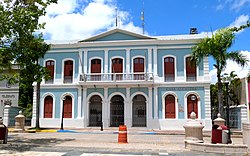
 The old Caguas City Hall is a museum | |
 Location of Caguas barrio-pueblo within the municipality of Caguas shown in red | |
| Coordinates: 18°14′02″N 66°02′00″W / 18.23393°N 66.033207°W[2] | |
| Commonwealth | |
| Municipality | |
| Area | |
• Total | 2.67 sq mi (6.9 km2) |
| • Land | 2.67 sq mi (6.9 km2) |
| • Water | 0 sq mi (0 km2) |
| Elevation | 233 ft (71 m) |
| Population (2020) | |
• Total | 19,020 |
| • Density | 8,391.8/sq mi (3,240.1/km2) |
| Source: 2010 Census | |
| Time zone | UTC−4 (AST) |
| ZIP Code | 00725, 00726, 00727 |
| Area code(s) | 787, 939 |
Caguas Pueblo is a barrio and downtown area that serves the administrative center (seat) of the city and municipality of Caguas, a municipality of Puerto Rico. It is bordered by the Cagüitas River to the north and located two miles southwest of the Río Grande de Loíza. Its population in 2020 was 19,020.[4][5][6][7]
As was customary in Spain, in Puerto Rico, the municipality has a barrio called pueblo (barrio-pueblo starting with the 1990 US Census) which contains a central plaza or main town square, the municipal buildings (such as the city hall), and a Catholic church. Fiestas patronales (patron saint festivals) are held in the main town square every year.[8][9] The municipal and mayoral offices were located in the City Hall building at the western edge of the main town square until 2010 when a new City Hall building located in the northwestern side of the downtown area was inaugurated.
The historic downtown district (pueblo) of Caguas was listed on the Puerto Rico Register of Historic Sites and Zones (Registro Nacional de Sitios y Zonas Históricas) on July 6, 1996, under the name Zona Histórica de Caguas.[10]
- ^ Puerto Rico: 2010 Population and Housing Unit Counts.pdf (PDF). U.S. Dept. of Commerce, Economics and Statistics Administration, U.S. Census Bureau. 2010.
- ^ a b "US Gazetteer 2019". US Census. US Government.
- ^ U.S. Geological Survey Geographic Names Information System: Caguas barrio-pueblo
- ^ Picó, Rafael; Buitrago de Santiago, Zayda; Berrios, Hector H. Nueva geografía de Puerto Rico: física, económica, y social, por Rafael Picó. Con la colaboración de Zayda Buitrago de Santiago y Héctor H. Berrios. San Juan Editorial Universitaria, Universidad de Puerto Rico,1969.
- ^ Gwillim Law (20 May 2015). Administrative Subdivisions of Countries: A Comprehensive World Reference, 1900 through 1998. McFarland. p. 300. ISBN 978-1-4766-0447-3. Retrieved 25 December 2018.
- ^ "US Census Barrio-Pueblo definition". factfinder.com. US Census. Archived from the original on 13 May 2017. Retrieved 5 January 2019.
- ^ "US Census: Caguas barrio-pueblo". Census. Retrieved 2024-04-22.
- ^ Cite error: The named reference
Santullanowas invoked but never defined (see the help page). - ^ Pariser, Harry S. (2003). Explore Puerto Rico, Fifth Edition. San Francisco: Manatee Press. pp. 52–55. Retrieved 10 February 2019.
- ^ GOBIERNO DE PUERTO RICO, JUNTA DE PLANIFICACIÓN DE PUERTO RICO (December 7, 2022). "REGISTRO DE PROPIEDADES DESIGNADAS POR LA JUNTA DE PLANIFICACIÓN DE PUERTO RICO" (PDF). jp.pr.gov.
