Cahill Expressway | |
|---|---|
 | |
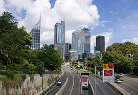
| Cahill Expressway and the Sydney CBD, as seen looking northwest from Art Gallery Road | |
| Coordinates |
|
| General information | |
| Type | Expressway |
| Length | 2.1 km (1.3 mi)[1] |
| Opened | 1958 |
| Gazetted | December 1964[2] |
| Route number(s) | (Harbour Tunnel–Woolloomooloo) |
| Former route number |
|
| Major junctions | |
| Northwest end | Bradfield Highway Millers Point, Sydney |
| Southeast end | |
| Location(s) | |
| Major suburbs / towns | The Rocks, Circular Quay |
| Highway system | |
| ---- | |
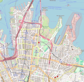
Cahill Expressway is an urban freeway in Sydney and was the first freeway constructed in Australia,[3] with the first section, from the Bradfield Highway to Conservatorium Place being opened to traffic in March 1958. It links the southern end of the Sydney Harbour Bridge, via an elevated roadway, a tunnel and cuttings between the Royal Botanic Garden and The Domain, to Woolloomooloo in Sydney's inner-eastern suburbs.
It is named after the then New South Wales Premier John Joseph Cahill, who also approved construction of the Sydney Opera House.
- ^ "Cahill Expressway" (Map). Google Maps. Retrieved 11 July 2023.
- ^ "Main Roads Act, 1924-1963". Government Gazette of the State of New South Wales. No. 137. National Library of Australia. 4 December 1964. p. 3910. Archived from the original on 15 May 2023. Retrieved 11 July 2023.
- ^ "1998 Special Article - The State of New South Wales - Timeline of History". Australian Bureau of Statistics. Retrieved 28 January 2007.
