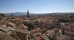
Calatayud | |
|---|---|
 | |
 Location in Aragon | |
| Coordinates: 41°21′0″N 1°38′0″W / 41.35000°N 1.63333°W | |
| Country | |
| Autonomous community | |
| Province | Zaragoza |
| Comarca | Comunidad de Calatayud |
| Judicial district | Calatayud |
| Government | |
| • Alcalde | José Manuel Aranda (PP) |
| Area | |
| • Total | 154 km2 (59 sq mi) |
| Elevation | 536 m (1,759 ft) |
| Population (2018)[1] | |
| • Total | 20,035 |
| • Density | 130/km2 (340/sq mi) |
| Demonym(s) | Bilbilitano, na |
| Time zone | UTC+1 (CET) |
| • Summer (DST) | UTC+2 (CEST) |
| Postal code | 50300 |
| Website | Official website |
Calatayud (Spanish pronunciation: [kalataˈʝuð]; 2014 pop. 20,658) is a municipality in the Province of Zaragoza, within Aragón, Spain, lying on the river Jalón, in the midst of the Sistema Ibérico mountain range. It is the second-largest town in the province after the capital, Zaragoza, and the largest town in Aragón other than the three provincial capitals. It is the seat of the comarca of Calatayud. Its population has been declining during the last decade due to migration.[2]
The town motto is Muy noble, leal, siempre augusta y fidelísima ciudad de Calatayud ("The very noble, loyal, always august and most faithful town of Calatayud").[3] The first democratic elections after General Franco's regime were called for 15 June 1977. In Calatayud they were held one day earlier than all the rest of Spain, in order to prepare for a visit there by King Juan Carlos I.
- ^ Municipal Register of Spain 2018. National Statistics Institute.
- ^ "Instituto nacional de estadística. (National statistics institute)". www.ine.es. Archived from the original on 2011-06-04. Retrieved 2009-05-31.
- ^ "goza-zaragoza-programa-fiestas-calatayud.pdf (application/pdf Object)" (PDF). Ayuntamiento de Calatayud. p. 14. Archived from the original (PDF) on 2011-07-11. Retrieved 2009-05-31.


