California, Maryland | |
|---|---|
 Patuxent River from the Governor Thomas Johnson Bridge | |
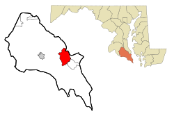
 Location of California, Maryland | |
| Coordinates: 38°18′20″N 76°29′40″W / 38.30556°N 76.49444°W | |
| Country | |
| State | |
| County | St. Mary's |
| Area | |
| • Total | 14.98 sq mi (38.80 km2) |
| • Land | 12.87 sq mi (33.32 km2) |
| • Water | 2.11 sq mi (5.48 km2) |
| Elevation | 105 ft (33 m) |
| Population (2020) | |
| • Total | 12,947 |
| • Density | 1,006.30/sq mi (388.53/km2) |
| Time zone | UTC−5 (Eastern (EST)) |
| • Summer (DST) | UTC−4 (EDT) |
| ZIP code | 20619 |
| Area code(s) | 301, 240 |
| FIPS code | 24-12150 |
| GNIS feature ID | 0594621 |
California is a census-designated place and community in St. Mary's County, Maryland, United States. The population was 11,857 at the 2010 census, an increase of 27.4% from the 2000 census.[2] California has been growing with the spread of population from the older adjacent community of Lexington Park and the growth in both technology-related and defense-related jobs at the Patuxent River Naval Air Station. There are department stores and numerous shopping centers situated along Maryland Highway 235 ("Three Notch Road"). Maryland Route 4 crosses Highway 235 in California, providing access to the wide Governor Thomas Johnson Bridge and the popular weekend resort town of Solomons on its opposite side. Bridge-bound traffic is notorious for backing up during rush hour.
- ^ "2020 U.S. Gazetteer Files". United States Census Bureau. Retrieved April 26, 2022.
- ^ Cite error: The named reference
2010CensusCaliforniaMDwas invoked but never defined (see the help page).