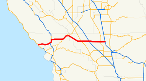
 SR 46 highlighted in red | ||||
| Route information | ||||
| Maintained by Caltrans | ||||
| Length | 110.696 mi[1] (178.148 km) SR 46 is broken into pieces, and the length does not reflect the US 101 overlap that would be required to make the route continuous. | |||
| History | State highway in 1916; numbered in 1964 | |||
| Major junctions | ||||
| West end | ||||
| ||||
| East end | ||||
| Location | ||||
| Country | United States | |||
| State | California | |||
| Counties | San Luis Obispo, Kern | |||
| Highway system | ||||
| ||||
State Route 46 (SR 46) is an east–west state highway in the U.S. state of California. It is a major crossing of the Coast Ranges and it is the southernmost crossing of the Diablo Range, connecting SR 1 on the Central Coast near Cambria and US 101 in Paso Robles with SR 99 at Famoso in the San Joaquin Valley.
The road that is now SR 46 was built and improved during the 1920s and was fully paved by 1930. The majority of SR 46 was originally designated as U.S. Route 466; however, after the latter was entirely removed from the U.S. Highway system, the eastern portion of the route became SR 46.
