| Camino Real de Tierra Adentro | |
|---|---|
 Map of El Camino Real de Tierra Adentro | |
| Location | Mexico and the United States |
| Governing body |
|
| Website | El Camino Real de Tierra Adentro National Historic Trail |
| Location | Mexico |
| Criteria | Cultural: (ii), (iv) |
| Reference | 1351 |
| Inscription | 6969 (4991st Session) |
| Area | 3,101.91 ha (7,665.0 acres) |
| Buffer zone | 268,057.2 ha (662,384 acres) |
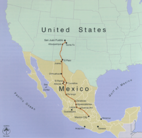
El Camino Real de Tierra Adentro (English: The Royal Road of the Interior Land), also known as the Silver Route,[1] was a Spanish 2,560-kilometre-long (1,590 mi) road between Mexico City and San Juan Pueblo (Ohkay Owingeh), New Mexico (in the modern U.S.), that was used from 1598 to 1882. It was the northernmost of the four major "royal roads" that linked Mexico City to its major tributaries during and after the Spanish colonial era.[2]
In 2010, 55 sites and five existing UNESCO World Heritage Sites along the Mexican section of the route were collectively added to the World Heritage List,[3] including historic cities, towns, bridges, haciendas and other monuments along the 1,400-kilometre (870 mi) route between the Historic Center of Mexico City (also a World Heritage Site on its own) and the town of Valle de Allende, Chihuahua.
The 404-mile (650 km) section of the route within the United States was proclaimed the El Camino Real de Tierra Adentro National Historic Trail, a part of the National Historic Trail system, on October 13, 2000. The historic route is overseen by both the National Park Service and the U.S. Bureau of Land Management with aid from the El Camino Real de Tierra Adentro Trail Association (CARTA). A portion of the trail near San Acacia, New Mexico, was listed on the U.S. National Register of Historic Places in 2014.[4]
- ^ World Heritage Convention, Unesco (29 June 2022). "Camino Real de Tierra Adentro". Unesco World Heritage Convention.
- ^ Snyder, Rachel Louise. "Camino Real Archived 1 December 2008 at the Wayback Machine" American Heritage, April/May 2004.
- ^ "Camino Real de Tierra Adentro – World Heritage List". UNESCO. Retrieved 5 August 2010.
- ^ "Weekly list of actions 11/03/14 through 11/07/14". National Park Service. Retrieved 23 November 2014.