Campbell County | |
|---|---|
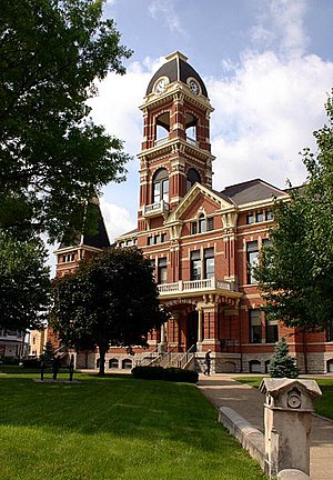
 The Campbell County Courthouse in Newport | |
 Location within the U.S. state of Kentucky | |
 Kentucky's location within the U.S. | |
| Coordinates: 38°57′N 84°23′W / 38.95°N 84.38°W | |
| Country | |
| State | |
| Founded | December 17, 1794 |
| Named for | John Campbell |
| Seat | Alexandria and Newport |
| Largest city | Fort Thomas |
| Area | |
| • Total | 159 sq mi (410 km2) |
| • Land | 151 sq mi (390 km2) |
| • Water | 8.1 sq mi (21 km2) 5.1% |
| Population (2020) | |
| • Total | 93,076 |
| • Estimate (2023) | 93,702 |
| • Density | 590/sq mi (230/km2) |
| Time zone | UTC−5 (Eastern) |
| • Summer (DST) | UTC−4 (EDT) |
| Congressional district | 4th |
| Website | www |
Campbell County is a county located in the northern part of the U.S. state of Kentucky. As of the 2020 census, the population was 93,076.[1] Its county seats are Alexandria and Newport.[2] The county was formed on December 17, 1794, from sections of Scott, Harrison, and Mason Counties[3][4] and was named for Colonel John Campbell (1735–1799), a Revolutionary War soldier and Kentucky legislator. Campbell County, with Boone and Kenton Counties, is part of the Northern Kentucky metro community, and the Cincinnati-Middletown, OH-KY-IN Metropolitan Statistical Area.
- ^ "State & County QuickFacts". United States Census Bureau. Retrieved June 29, 2022.
- ^ Nolan v. Campbell County Fiscal Court Kentucky Court of Appeals. November 24, 2010. Retrieved May 28, 2015.
- ^ "Campbell County Kentucky GenWeb".
- ^ "Campbell County". The Kentucky Encyclopedia. 2000. Archived from the original on October 1, 2018. Retrieved August 21, 2014.