| Camperdown Sydney, New South Wales | |||||||||||||||
|---|---|---|---|---|---|---|---|---|---|---|---|---|---|---|---|
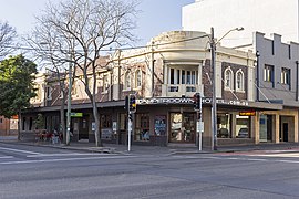
 Camperdown Hotel on the corner of Parramatta Rd and Layton St | |||||||||||||||
 | |||||||||||||||
| Population | 9,381 (2021 census)[1] | ||||||||||||||
| • Density | 6,250/km2 (16,200/sq mi) | ||||||||||||||
| Postcode(s) | 2050 | ||||||||||||||
| Elevation | 25 m (82 ft) | ||||||||||||||
| Area | 1.5 km2 (0.6 sq mi) | ||||||||||||||
| Location | 4 km (2 mi) SW of Sydney CBD | ||||||||||||||
| LGA(s) | |||||||||||||||
| State electorate(s) | |||||||||||||||
| Federal division(s) | |||||||||||||||
| |||||||||||||||
Camperdown is an inner western suburb of Sydney, in the state of New South Wales, Australia. Camperdown is located 4 kilometres south-west of the Sydney central business district and is part of the Inner West region. Camperdown lies across the local government areas of the City of Sydney and Inner West Council.
Camperdown is a heavily populated suburb and is home to the Royal Prince Alfred Hospital, the University of Sydney and the historic Camperdown Cemetery.[2] It was also once home to the Royal Alexandra Hospital for Children, which was relocated to be next to Westmead Hospital in Sydney's west. The hospital buildings and grounds have been redeveloped into apartment complexes.
- ^ Australian Bureau of Statistics (28 June 2022). "Camperdown". 2021 Census QuickStats. Retrieved 13 November 2024.
- ^ "Camperdown". Raine & Horne Newtown. Retrieved 14 December 2023.