This article needs to be updated. (August 2022) |
Canajoharie, New York | |
|---|---|
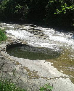
 The "pot that washes itself" located just south of the Village of Canajoharie on the Canajoharie Creek | |
| Coordinates: 42°54′11″N 74°34′16″W / 42.90306°N 74.57111°W | |
| Country | United States |
| State | New York |
| County | Montgomery |
| Town | Canajoharie |
| Government | |
| • Type | Mayor-Council government |
| • Mayor | Austin Countryman |
| • Village Board | Trustees |
| Area | |
| • Total | 1.40 sq mi (3.62 km2) |
| • Land | 1.33 sq mi (3.45 km2) |
| • Water | 0.07 sq mi (0.18 km2) |
| Elevation | 305 ft (93 m) |
| Population (2020) | |
| • Total | 2,037 |
| • Density | 1,530.43/sq mi (590.99/km2) |
| Time zone | UTC-5 (Eastern (EST)) |
| • Summer (DST) | UTC-4 (EDT) |
| ZIP code | 13317 |
| Area code | 518 |
| FIPS code | 36-12111 |
| GNIS feature ID | 0945734 |
Canajoharie (/ˌkænədʒəˈhɛəri/) is a village in the Town of Canajoharie in Montgomery County, New York, United States. As of the 2010 census, the village had a population of 2,229.[2] The name is said to be a Mohawk language term meaning "the pot that washes itself," referring to the "Canajoharie Boiling Pot," a circular gorge in the Canajoharie Creek, just south of the village.
The village of Canajoharie is at the north border of the Town of Canajoharie; it is west of Amsterdam and east of Utica. The village and town name also refer to Canajoharie, a historic Mohawk town that was located west of here, referred to by the English colonists as the "Upper Castle." A church stands at that site from the pre-revolutionary era; the Mohawk Upper Castle Historic District is a National Historic Landmark.
The village of Canajoharie was home to one of a handful of operating "dummy lights" in the United States, located downtown at the intersection of Church, Mohawk and Montgomery Streets (also known as Wagner Square). It is a traffic signal on a pedestal located in the middle of an intersection; the light was first installed in 1926. After a couple of serious motor vehicle accidents which occurred in 2021, the dummy light was removed from Wagner Square and hasn't been back since due to possible legal risks.[3][4] Two others are currently located in New York State, in Beacon and Croton-on-Hudson.
The Erie Canal passes the north side of the village.
The village was the headquarters for the manufacturing operations of the Beech-Nut baby food company from its founding in 1891 until the plant was closed in March 2011 with production moving to the town of Florida in the same county, on the south side of the river.[5][6]
In 2015 most of the village (and a small area to its south) was listed on the National Register of Historic Places as the Canajoharie Historic District,[7] due to its importance as a transportation hub over its existence and the well-preserved architecture from different eras.[8] In addition, the Bragdon-Lipe House, the Van Alstyne Homestead, the West Hill School, and the United States Post Office are individually listed on the National Register of Historic Places.[9]
- ^ "ArcGIS REST Services Directory". United States Census Bureau. Retrieved September 20, 2022.
- ^ "U.S. Census website". United States Census Bureau. Retrieved May 13, 2018.
- ^ The Leader-Herald, Dievendorf takes Canajoharie mayor’s race, ticket sweeps, Tyler A. McNeil, March 22, 2023, Retrieved July 10, 2023.
- ^ The Recorder, Village of Canajoharie to permanently move historic dummy light out of Wagner Square, Shenandoah Briere, August 10, 2022, Retrieved July 10, 2023.
- ^ "Beech-Nut ends production in Canajoharie", The Leader-Herald, March 27, 2011
- ^ "Beech-Nut site drawing some interest", The Leader-Herald, June 28, 2011
- ^ "National Register of Historic Places listings for May 29, 2015". U.S. National Park Service. May 29, 2015. Retrieved June 5, 2015.
- ^ "Governor Cuomo Announces 22 Properties Nominated to State and National Registers of Historic Places" (Press release). Albany, NY. New York State Governor's Press Office. March 25, 2015. Retrieved June 5, 2015.
- ^ "National Register Information System". National Register of Historic Places. National Park Service. July 9, 2010.
