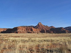
Cane Beds, Arizona | |
|---|---|
 Cane Beds Road in 2004 | |
| Coordinates: 36°56′03″N 112°54′42″W / 36.93417°N 112.91167°W | |
| Country | |
| State | |
| County | Mohave |
| Area | |
• Total | 8.29 sq mi (21.46 km2) |
| • Land | 8.29 sq mi (21.46 km2) |
| • Water | 0.00 sq mi (0.00 km2) |
| Elevation | 5,046 ft (1,538 m) |
| Population | |
• Total | 466 |
| • Density | 56.25/sq mi (21.72/km2) |
| Time zone | UTC-7 (MST) |
| ZIP Code | 86022 |
| FIPS code | 04-09900 |
| GNIS feature ID | 2582747 |
Cane Beds is an unincorporated community and census-designated place (CDP) in Mohave County, Arizona, United States. It lies 4 miles (6 km) south of the border with Utah in the Arizona Strip, and is supported by services in Utah as well as some in Nevada.
The population was 466 at the 2020 census.[3] The community is historically Mormon, and presently also includes several families from breakaway Mormon groups. It has a small tourism industry because of nearby scenic hiking trails.
- ^ "2021 U.S. Gazetteer Files: Arizona". United States Census Bureau. Retrieved May 19, 2022.
- ^ "Feature Detail Report for: Cane Beds Census Designated Place". Geographic Names Information System. United States Geological Survey, United States Department of the Interior.
- ^ a b "Cane Beds CDP, Arizona: 2020 DEC Redistricting Data (PL 94-171)". U.S. Census Bureau. Retrieved May 19, 2022.

