| Canowindra New South Wales | |||||||||
|---|---|---|---|---|---|---|---|---|---|
 | |||||||||
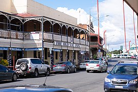
 Main town of Canowindra (top). Aerial photo of the town (bottom). | |||||||||
| Coordinates | 33°34′0″S 148°40′0″E / 33.56667°S 148.66667°E | ||||||||
| Population | 2,832 (2021 census)[1] | ||||||||
| Established | 1847 | ||||||||
| Postcode(s) | 2804 | ||||||||
| Elevation | 300 m (984 ft) | ||||||||
| Location | |||||||||
| LGA(s) | Cabonne Shire | ||||||||
| State electorate(s) | Orange | ||||||||
| Federal division(s) | Calare | ||||||||
| |||||||||
Situated on the Belubula River, Canowindra (pronounced /kəˈnaʊndrə/ kə-NOWN-drə[2]) is a historic township and the largest population centre in Cabonne Shire. The town is located between Orange and Cowra in the central west of New South Wales, Australia. The curving main street, Gaskill Street, is partly an urban conservation area.
- ^ Australian Bureau of Statistics (28 June 2022). "Canowindra". 2021 Census QuickStats. Retrieved 28 June 2022.
 Material was copied from this source, which is available under a Creative Commons Attribution 4.0 International License Archived 2022-06-29 at the Wayback Machine.
- ^ Macquarie Dictionary, Fourth Edition (2005). Melbourne, The Macquarie Library Pty Ltd. ISBN 1-876429-14-3
