| Cantabrian Mountains | |
|---|---|
| Spanish: Cordillera Cantábrica | |
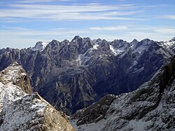
 Cantabrian Mountains parallel to the Cantabrian Sea seen from Castro Valnera in an east-west direction. In the background, the Montaña Palentina (left) and the Picos de Europa (right) | |
| Highest point | |
| Peak | Torre de Cerredo |
| Elevation | 2,648 m (8,688 ft) |
| Coordinates | 43°11′51″N 04°51′06″W / 43.19750°N 4.85167°W |
| Dimensions | |
| Length | 300 km (190 mi) WE |
| Width | 50 km (31 mi) NS |
| Naming | |
| Etymology | Named after the Cantabri |
| Geography | |
| Country | Spain |
| Communities | |
| Range coordinates | 43°N 5°W / 43°N 5°W |
| Borders on | |
| Geology | |
| Rock age(s) | Carboniferous, Paleozoic, Mesozoic |
| Rock type | Limestone |


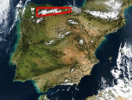
The Cantabrian Mountains or Cantabrian Range (Spanish: Cordillera Cantábrica) are one of the main systems of mountain ranges in Spain. They stretch for over 300 km (180 miles) across northern Spain, from the western limit of the Pyrenees to the Galician Massif in Galicia, along the coast of the Cantabrian Sea. Their easternmost end meets the Sistema Ibérico.
These mountains are a distinct physiographic province of the larger Alpine System physiographic division.
The Cantabrian Mountains offer a wide range of trails for hiking, as well as many challenging climbing routes. Skiing is possible in the ski resorts of Alto Campoo, Valgrande-Pajares, Fuentes de Invierno, San Isidro, Leitariegos and Manzaneda.
