Cape Sorrell | |
|---|---|
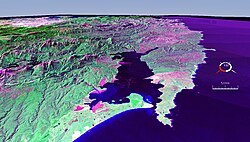
 False colour Landsat image showing Macquarie Harbour with Cape Sorell in the centre right area of the picture. | |
Location in Tasmania | |
| Coordinates: 42°11′24″S 145°09′36″E / 42.19000°S 145.16000°E | |
| Location | West Coast, Tasmania, Australia |
Cape Sorell is a headland located in the Southern Ocean outside Macquarie Harbour on the West Coast of Tasmania, Australia. The cape and the Cape Sorell Lighthouse, located above the headland, are important orientation points for all vessels entering the Macquarie Heads and then through Hells Gates at the entrance to the harbour.
Cape Sorrell is named in honour of William Sorell, Lieutenant-Governor of Tasmania from 1817 to 1824.
It is a regularly cited feature of the west coast of Tasmania - for many systems as an indicator the northernmost point of the region South West Tasmania.[1][2]
- ^ Hills, Loftus; Tasmania. Department of Mines (1914), Geological reconnaissance of the country between Cape Sorell and Point Hibbs, Dept. of Mines, retrieved 13 February 2018
- ^ Prince, Brian; Tasmania. Dept. of Parks, Wildlife and Heritage; Australian Heritage Commission (1992), Aboriginal archaeological sites on the West Coast of Tasmania : port Davey to Cape Sorell : a report to the Tasmanian Department of Parks, Wildlife and Heritage, Dept. of Parks, Wildlife and Heritage, retrieved 13 February 2018
