Cape Spear | |
|---|---|
 | |
| Coordinates: 47°31′25″N 52°37′10″W / 47.52361°N 52.61944°W | |
| Location | Newfoundland, Canada |
| Elevation | 75 m (246 ft) |
| Topo map | NTS 1N10 St. John's |
| Current light | |
 | |
| Constructed | 1955 |
| Construction | concrete |
| Height | 13.7 m (45 ft) |
| Markings | white (tower), white (lantern), red (guard rail) |
| Operator | Parks Canada |
| Heritage | recognized federal heritage building of Canada |
| Focal height | 71 m (233 ft) |
| Range | 20 nmi (37 km; 23 mi) |
| Characteristic | Fl(3) W 15s |
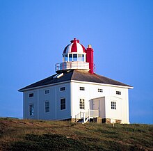
| Original light[2] | |
 | |
| Constructed | 1836 |
| Construction | limestone |
| Markings | white (tower), white (lantern), red and white (dome) |
| Heritage | national Historic Sites of Canada, classified federal heritage building of Canada, heritage lighthouse |
| Deactivated | 1955 |
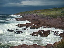
Cape Spear (French: Cap d'Espoir) is a headland located on the Avalon Peninsula of Newfoundland near St. John's in the Canadian province of Newfoundland and Labrador. At a longitude of 52°37' W, it is the easternmost point in Canada and North America, excluding Greenland.[1]
Cape Spear is within the municipal boundaries of the city of St. John's, located about 12 kilometres (7.5 mi) from downtown St. John's.[3]
The Portuguese named this location Cabo da Esperança, meaning "cape of hope", which became Cap d'Espoir in French and finally "Cape Spear".
Cape Spear is the trailhead/trail end for two components of the East Coast Trail.[4]
- ^ a b Staveley, Michael (February 6, 2006). "Cape Spear". The Canadian Encyclopedia. Retrieved August 21, 2019.
- ^ Rowlett, Russ. "Lighthouses of Canada: Southeastern Newfoundland". The Lighthouse Directory. University of North Carolina at Chapel Hill. Retrieved December 30, 2015.
- ^ "Cape Spear Lighthouse National Historic Site". Newfoundland and Labrador Tourism. Retrieved August 21, 2019.
- ^ Brown, David; Findlay, Arthur (2008). 501 Must-Take Journeys. Octopus Publishing Group. ISBN 978-0-7537-1592-5.


