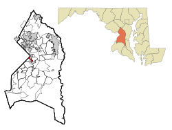
Capitol Heights, Maryland | |
|---|---|
 Location of Capitol Heights, Maryland | |
| Coordinates: 38°52′55″N 76°54′52″W / 38.88194°N 76.91444°W | |
| Country | |
| State | |
| County | |
| Incorporated | 1910[1] |
| Area | |
| • Total | 0.78 sq mi (2.02 km2) |
| • Land | 0.78 sq mi (2.02 km2) |
| • Water | 0.00 sq mi (0.00 km2) |
| Elevation | 121 ft (37 m) |
| Population (2020) | |
| • Total | 4,050 |
| • Density | 5,185.66/sq mi (2,002.72/km2) |
| Time zone | UTC-5 (Eastern (EST)) |
| • Summer (DST) | UTC-4 (EDT) |
| ZIP codes | 20700-20799 |
| Area code(s) | 301, 240 |
| FIPS code | 24-13000 |
| GNIS feature ID | 0597177 |
| Website | www |
Capitol Heights is a town in Prince George's County, Maryland, United States, located on the border of both the Northeast & Southeast quadrants of Washington. Per the 2020 census, the population was 4,050.[3] The town of Capitol Heights is officially bounded between Southern Avenue NE/SE to the north, Yost Place, and Eastern Avenue NE to the east, the Watts Branch Stream, Brooke Road, and Capitol Heights Boulevard to the south, and Marlboro Pike to the west. The zip code of Capitol Heights is 20743.
- ^ "Capitol Heights". Maryland Manual. Retrieved June 27, 2017.
- ^ "2020 U.S. Gazetteer Files". United States Census Bureau. Retrieved April 26, 2022.
- ^ "Capitol Heights town, Maryland". United States Census Bureau. Retrieved April 15, 2022.


