 | |
 | |
| Location | Carmanah Point British Columbia Canada |
|---|---|
| Coordinates | 48°36′42.1″N 124°45′04.7″W / 48.611694°N 124.751306°W |
| Tower | |
| Constructed | 1891 (first) |
| Construction | concrete tower |
| Height | 11 metres (36 ft) |
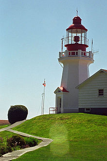
| Shape | octagonal tower with balcony and lantern |
| Markings | white tower, red lantern house |
| Operator | Canadian Coast Guard |
| Heritage | recognized federal heritage building of Canada, heritage lighthouse |
| Light | |
| First lit | 1920 (current) |
| Focal height | 55.5 metres (182 ft) |
| Range | 37 kilometres (23 mi) |
| Characteristic | Fl W 5 s. |
Carmanah Point Light Station is a lighthouse on the southwest coast of Vancouver Island at the entrance from the Pacific Ocean to the Salish Sea Formerly know as Jaun deFuca Strait.[1]
- ^ Rowlett, Russ. "Lighthouses of Canada: Southern British Columbia". The Lighthouse Directory. University of North Carolina at Chapel Hill. Retrieved December 26, 2015.