Carmel, Indiana | |
|---|---|
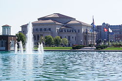
 The Palladium at the Center for the Performing Arts and Carmel City Center | |
| Motto: "A Partnership for Tomorrow" | |
| Coordinates: 39°58′05″N 86°06′45″W / 39.96806°N 86.11250°W | |
| Country | United States |
| State | Indiana |
| County | Hamilton |
| Township | Clay (coterminous) |
| Government | |
| • Mayor | Sue Finkam (R) (2024–present)[1][2] |
| Area | |
| • Total | 50.17 sq mi (129.94 km2) |
| • Land | 49.09 sq mi (127.13 km2) |
| • Water | 1.08 sq mi (2.80 km2) |
| Elevation | 843 ft (257 m) |
| Population (2020)[5] | |
| • Total | 99,757 |
| • Estimate (2021) | 100,777 |
| • Density | 2,032.3/sq mi (784.7/km2) |
| Time zone | UTC−5 (EST) |
| • Summer (DST) | UTC−4 (EDT) |
| ZIP codes | 46032, 46033, 46074, 46082, 46280, 46290[6] |
| Area code(s) | 317, 463 |
| FIPS code | 18-10342 |
| GNIS feature ID | 2393750[4] |
| Website | www |
Carmel (/ˈkɑːrməl/) is a suburban city in Hamilton County, Indiana, United States, immediately north of Indianapolis. With a population of 99,757 as of the 2020 census, the city spans 49 square miles (130 km2) across Clay Township and is bordered by the White River to the east and the Boone County line to the west. Carmel was home to one of the first electronic automated traffic signals in the country,[7] and has now constructed 141 roundabouts between 1988 and 2022.[8][9]
- ^ Howell Jr., James (November 8, 2023). "Sue Finkam elected mayor of Carmel after 28 years of Jim Brainard". WRTV Indianapolis. Retrieved December 27, 2023.
- ^ Tuohy, John (November 8, 2023). "The Indianapolis Star Subscription Offers, Specials, and Discounts". Indianapolis Star. Retrieved December 27, 2023.
- ^ "2020 U.S. Gazetteer Files". United States Census Bureau. Retrieved March 16, 2022.
- ^ a b U.S. Geological Survey Geographic Names Information System: Carmel, Indiana
- ^ Cite error: The named reference
2021censusestwas invoked but never defined (see the help page). - ^ "ZIP Code by City and State - Carmel, IN". United States Postal Service. Retrieved July 4, 2021.
- ^ Contreras, Natalia (January 1, 2019). "Carmel loves roundabouts: Here's why". The Indianapolis Star. Retrieved December 1, 2019.
- ^ "Roundabout Index: Carmel, IN". No more corners. All About Roundabout Society. November 23, 2017. Retrieved November 1, 2021.
- ^ "City of Carmel". carmel.in.gov. Retrieved September 27, 2022.


