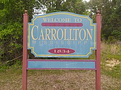
Carrollton, Mississippi | |
|---|---|
 | |
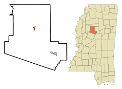
 Location of Carrollton, Mississippi | |
| Coordinates: 33°30′18″N 89°55′22″W / 33.50500°N 89.92278°W | |
| Country | United States |
| State | Mississippi |
| County | Carroll |
| Area | |
| • Total | 0.81 sq mi (2.11 km2) |
| • Land | 0.81 sq mi (2.11 km2) |
| • Water | 0.00 sq mi (0.00 km2) |
| Elevation | 289 ft (88 m) |
| Population (2020) | |
| • Total | 423 |
| • Density | 520.30/sq mi (200.92/km2) |
| Time zone | UTC-6 (Central (CST)) |
| • Summer (DST) | UTC-5 (CDT) |
| ZIP code | 38917 |
| Area code | 662 |
| FIPS code | 28-11580 |
| GNIS feature ID | 0668097 |
| Website | www |
Carrollton is a town in and the second county seat of Carroll County, Mississippi, United States, which is within the Mississippi Delta. The population was 190 at the 2010 census,[2] down from 408 in 2000. Centrally located in the county, the town is part of the Greenwood, Mississippi micropolitan area. The first county seat, Vaiden, was founded in the eastern part of the county during its early settlement.
- ^ "2020 U.S. Gazetteer Files". United States Census Bureau. Retrieved July 24, 2022.
- ^ "Geographic Identifiers: 2010 Demographic Profile Data (G001): Carrollton town, Mississippi". U.S. Census Bureau, American Factfinder. Archived from the original on February 12, 2020. Retrieved October 2, 2014.