 The eastern portal of Cascade Tunnel in 2012 | |
| Overview | |
|---|---|
| Line | BNSF Scenic Subdivision (formerly Burlington Northern and Great Northern) |
| Location | Stevens Pass, Washington, U.S. |
| Coordinates | 47°44′33″N 121°04′10″W / 47.74250°N 121.06944°W |
| Status | Active |
| Crosses | Cascade Range, near Stevens Pass |
| Operation | |
| Opened | 1929, 95 years ago[1][2] |
| Traffic | Railroad |
| Character | Primarily freight service Some passenger service (Amtrak) |
| Technical | |
| Length | 7.80 miles (12.55 km) |
| No. of tracks | Single |
| Track gauge | 4 ft 8+1⁄2 in (1,435 mm) standard gauge |
| Highest elevation | 2,881 feet (880 m) |
| Route map | |
 | |
 | |
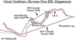
The Cascade Tunnel refers to two railroad tunnels, its original tunnel and its replacement, in the northwest United States, east of the Seattle metropolitan area in the Cascade Range of Washington, at Stevens Pass. It is approximately 65 miles (105 km) east of Everett, with both portals adjacent to U.S. Route 2. Both single-track tunnels were constructed by the Great Northern Railway.
The first was 2.63 miles (4.23 km) in length and opened in 1900 to avoid problems caused by heavy winter snowfalls on the original line that had eight zig zags (switchbacks). The current tunnel is 7.8 miles (12.6 km) in length and entered service in early 1929,[1][2] approximately 1.5 miles (2.4 km) south of and 500 feet (150 m) lower in elevation than the original. The present east portal is nearly four miles (6.5 km) east of the original and is at 2,881 feet (878 m) above sea level, 1,180 feet (360 m) below the pass. The tunnel connects Berne in Chelan County on its east with Scenic Hot Springs in King County on its west and is the longest railroad tunnel in the United States.
- ^ a b "Great tunnel opening ready". Spokane Daily Chronicle. (Washington). Associated Press. January 12, 1929. p. 1.
- ^ a b "Wheels thunder in wonder bore". Spokesman-Review. (Spokane, Washington). January 13, 1929. p. 1, part 1.