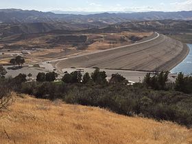
| Castaic Dam | |
|---|---|
 View from the northeast. | |
| Location | Castaic, United States |
| Coordinates | 34°31′10″N 118°36′25″W / 34.5194°N 118.6070°W |
| Opening date | 1973 |
| Dam and spillways | |
| Type of dam | Earthfill |
| Impounds | Castaic Creek |
| Height | 340 ft (100 m)[1] |
| Length | 5,200 ft (1,600 m)[1] |
| Dam volume | 44,000,000 cu yd (34,000,000 m3)[1] |
| Spillway type | Uncontrolled overflow |
| Reservoir | |
| Creates | Castaic Lake |
| Total capacity | 325,000 acre⋅ft (401,000,000 m3)[1] |
| Catchment area | 153.7 sq mi (398 km2)[1] |
| Surface area | 2,235 acres (904 ha)[1] |
| Power Station | |
| Installed capacity | 11 MW |
Castaic Dam is an embankment dam in northwestern Los Angeles County, California, in the unincorporated area of Castaic. Although located on Castaic Creek, a major tributary of the Santa Clara River, Castaic Creek provides little of its water. The lake is the terminus of the West Branch of the California Aqueduct, part of the State Water Project. The dam was built by the California Department of Water Resources and construction was completed in 1973. The lake has a capacity of 325,000 acre-feet (401,000,000 m3) and stores drinking water for the western portion of the Greater Los Angeles Area.