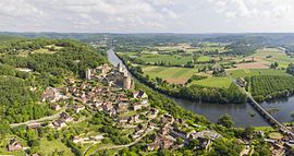
Castelnaud-la-Chapelle | |
|---|---|
 View of Castelnaud-la-Chapelle and its castle | |
| Coordinates: 44°48′57″N 1°08′58″E / 44.8158°N 1.1494°E | |
| Country | France |
| Region | Nouvelle-Aquitaine |
| Department | Dordogne |
| Arrondissement | Sarlat-la-Canéda |
| Canton | Vallée Dordogne |
| Government | |
| • Mayor (2020–2026) | Daniel Dejean[1] |
| Area 1 | 20.88 km2 (8.06 sq mi) |
| Population (2021)[2] | 447 |
| • Density | 21/km2 (55/sq mi) |
| Time zone | UTC+01:00 (CET) |
| • Summer (DST) | UTC+02:00 (CEST) |
| INSEE/Postal code | 24086 /24250 |
| Elevation | 51–283 m (167–928 ft) (avg. 71 m or 233 ft) |
| 1 French Land Register data, which excludes lakes, ponds, glaciers > 1 km2 (0.386 sq mi or 247 acres) and river estuaries. | |
Castelnaud-la-Chapelle (French pronunciation: [kastɛlno la ʃapɛl]; Occitan: Castelnòu e La Capèla) is a commune in the Dordogne department in Nouvelle-Aquitaine in southwestern France. It was created in 1973 by the merger of two former communes: Castelnaud-Fayrac and La Chapelle-Péchaud.[3] It is a member of Les Plus Beaux Villages de France (The Most Beautiful Villages of France) Association.
The Château de Castelnaud-la-Chapelle is located in the commune.
- ^ "Répertoire national des élus: les maires" (in French). data.gouv.fr, Plateforme ouverte des données publiques françaises. 4 May 2022.
- ^ "Populations légales 2021" (in French). The National Institute of Statistics and Economic Studies. 28 December 2023.
- ^ Modifications aux circonscriptions administratives territoriales (fusion de communes), Journal officiel de la République française n° 0024, 28 January 1973, pp. 1114-1117.


