| Castlecrag Sydney, New South Wales | |||||||||||||||
|---|---|---|---|---|---|---|---|---|---|---|---|---|---|---|---|
 Middle Harbour, view from Castlecrag | |||||||||||||||
 | |||||||||||||||
| Coordinates | 33°48′05″S 151°13′12″E / 33.80137°S 151.22007°E | ||||||||||||||
| Population | 2,965 (2021 census)[1] | ||||||||||||||
| • Density | 1,772.5/km2 (4,591/sq mi) | ||||||||||||||
| Established | 1860s | ||||||||||||||
| Postcode(s) | 2068 | ||||||||||||||
| Elevation | 85 m (279 ft) | ||||||||||||||
| Area | 1.5 km2 (0.6 sq mi) | ||||||||||||||
| Location | 8 km (5 mi) north of Sydney CBD | ||||||||||||||
| LGA(s) | City of Willoughby | ||||||||||||||
| State electorate(s) | Willoughby | ||||||||||||||
| Federal division(s) | North Sydney | ||||||||||||||
| |||||||||||||||

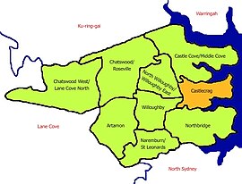
Castlecrag is a suburb on the lower North Shore of Sydney, in the state of New South Wales, Australia 8 kilometres north of the Sydney central business district, in the local government area of the City of Willoughby.
Castlecrag is a suburb of historical significance that is bounded to the north, east and south by Middle Harbour and to the west by Eastern Valley Way.[2] Castlecrag shares its postcode, 2068, with the surrounding suburbs of Willoughby, Middle Cove and North Willoughby.[3]
- ^ Cite error: The named reference
ABSwas invoked but never defined (see the help page). - ^ "History | Castlecrag Community". 27 September 2014. Retrieved 15 December 2023.
- ^ "Archived copy". Archived from the original on 23 March 2007. Retrieved 23 March 2007.
{{cite web}}: CS1 maint: archived copy as title (link) Australian White Pages Find a Postcode.
