Castlerahan
Caisleán Raithin (Irish) | |
|---|---|
 View of Lough Ramor | |
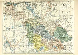
 Barony map of County Cavan, 1900; Castlerahan is in the southeast, coloured peach. | |
| Sovereign state | Ireland |
| Province | Ulster |
| County | Cavan |
| Area | |
| • Total | 280.36 km2 (108.25 sq mi) |
Castlerahan (Irish: Caisleán Raithin[1]) is a barony in County Cavan, Ireland.[2] Baronies were mainly cadastral rather than administrative units. They acquired modest local taxation and spending functions in the 19th century before being superseded by the Local Government (Ireland) Act 1898.[3][4]
- ^ "Caisleán Raithin/Castlerahan". Logainm.ie.
- ^ General Alphabetical Index to the Townlands and Towns, Parishes, and Baronies of Ireland: Based on the Census of Ireland for the Year 1851. Genealogical Publishing Com. 22 February 1984. ISBN 9780806310527 – via Google Books.
- ^ Sharp, James A. (22 February 1852). "A new gazetteer; or topographical dictionary of the British islands and narrow seas". LONGMAN, BROWN – via Google Books.
- ^ General Register Office of Ireland (1904). "Alphabetical index to the baronies of Ireland". Census of Ireland 1901: General topographical index. Command papers. Vol. Cd. 2071. HMSO. pp. 966–978.