| Castlewood Canyon State Park | |
|---|---|
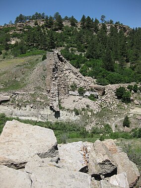
 Remnants of Castlewood Dam | |
| Location | Douglas County, Colorado, USA |
| Nearest city | Castle Rock, CO |
| Coordinates | 39°19′47″N 104°44′19″W / 39.32972°N 104.73861°W |
| Area | 2,621 acres (10.61 km2) |
| Established | 1964 |
| Visitors | 252,422 (in 2021)[1] |
| Governing body | Colorado Parks and Wildlife |
| Website | https://cpw.state.co.us/state-parks/castlewood-canyon-state-park |
Castlewood Canyon State Park is a Colorado state park near Franktown, Colorado. The park retains a unique part of Colorado's history, the remains of Castlewood Canyon Dam. Visitors can still see the remnants and damage from that dam which burst in 1933. The event sent a 15-foot (5 m) wave of water all the way to downtown Denver resulting in a flood. Also contained within the park is the historic Cherry Creek Bridge.
- ^ "Colorado State Parks Region Annual Visitation Report" (PDF). Colorado Counties, Inc. 2023.
