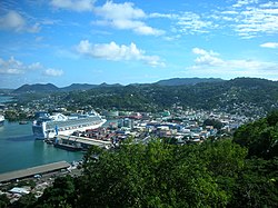
Castries District | |
|---|---|
 Port of Castries | |
 Location of Castries District within Saint Lucia | |
| Coordinates (Town of Castries): 13°59′17″N 60°58′25″W / 13.98806°N 60.97361°W[1] | |
| Country | St. Lucia |
| Area | |
| • Land | 90.33 km2 (34.88 sq mi) |
| Population (2010)[2] | |
| • Total | 65,656 |
| • Density | 726.85/km2 (1,882.5/sq mi) |
| ISO 3166-2:LC | LC-02 |
Castries District is one of 10 districts (formerly called quarters) of the Caribbean island nation of Saint Lucia. According to the 2012 census, the population of the district was 80,573, having shown a slow but steady increase over the past ten years.[1] The capital of Saint Lucia, the city of Castries, is located in this district. During the Saint Lucia Jazz Festival, the city of Castries plays host to several stages.[3][4][5]
- ^ "Castries". GeoNames. Retrieved August 16, 2021.
- ^ "CASTRIES" (PDF). The Central Statistical Office of Saint Lucia. Retrieved September 29, 2022.
- ^ "Population by District". Saint Lucian Statistics. Archived from the original on November 24, 2007. Retrieved January 21, 2006.
- ^ "Castries first level administrative region". National Geospatial Intelligence Agency. Retrieved August 8, 2021.
- ^ "Map of Castries District" (PDF). Statistical Office of Saint Lucia. Retrieved August 16, 2021.