| Cave Hill | |
|---|---|
| Binn Uamha | |
 | |
| Highest point | |
| Elevation | 368 m (1,207 ft) |
| Coordinates | 54°38′49″N 5°57′04″W / 54.647°N 5.951°W |
| Geography | |
 | |
| Location | near Belfast, County Antrim, Northern Ireland |
| Climbing | |
| Easiest route | Hike |
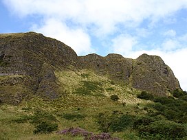
Cave Hill or Cavehill[1] is a rocky hill overlooking the city of Belfast, Northern Ireland,with a height of 368 metres (1,207 ft). It is marked by basalt cliffs and caves, and its distinguishing feature is 'Napoleon's Nose',[2] a tall cliff resembling the profile of the emperor Napoleon. On top of this are the remains of an ancient promontory fort called McArt's Fort. Cavehill was also historically called 'Ben Madigan' (from Irish: Beann Mhadagáin, "Madagán’s peak"), after a king of Ulster called Madagán.[1]
It forms part of the Belfast Hills and marks the southeastern edge of the Antrim Plateau. All of Belfast can be seen from its peak, as can the Isle of Man and Scotland on clear days. Like Arthur's Seat in Edinburgh, it lies just a few miles from the centre of a major city.[citation needed]
Cave Hill is thought to be the inspiration for Jonathan Swift's Gulliver's Travels. Swift imagined that Cave Hill resembled the shape of a sleeping giant safeguarding the city.[3]
- ^ a b Northern Ireland Place-Names Project. "Cave Hill".
- ^ BBC News website
- ^ "Belfast Hills". Discover Northern Ireland. Northern Ireland Tourist Board. Retrieved 18 May 2007.