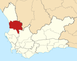
Cederberg | |
|---|---|
 Location in the Western Cape | |
| Coordinates: 32°15′S 19°00′E / 32.250°S 19.000°E | |
| Country | South Africa |
| Province | Western Cape |
| District | West Coast |
| Seat | Clanwilliam |
| Wards | 6 |
| Government | |
| • Type | Municipal council |
| • Mayor | Ruben Richards (CFRA) |
| Area | |
| • Total | 8,007 km2 (3,092 sq mi) |
| Population (2022)[2] | |
| • Total | 55,108 |
| • Density | 6.9/km2 (18/sq mi) |
| Racial makeup (2022) | |
| • Black African | 21.8% |
| • Coloured | 68.9% |
| • Indian/Asian | 0.1% |
| • White | 7.9% |
| First languages (2011) | |
| • Afrikaans | 88.7% |
| • Xhosa | 5.0% |
| • Sotho | 2.5% |
| • English | 1.9% |
| • Other | 1.9% |
| Time zone | UTC+2 (SAST) |
| Municipal code | WC012 |
Cederberg Municipality (Afrikaans: Cederberg Munisipaliteit) is a local municipality which governs an area of the Western Cape province of South Africa stretching from the Cederberg mountains through the middle valley of the Olifants River to the Atlantic coast. It includes the towns of Clanwilliam, Citrusdal and Lamberts Bay, and the surrounding villages and farms. As of 2011[update] it had a population of 49,768.[3] It is located within the West Coast District Municipality and its municipality code is WC012.
- ^ "Executive Mayor". 26 August 2015.
- ^ "Statistics by place". Statistics South Africa. Retrieved 7 August 2024.
- ^ a b c "Statistics by place". Statistics South Africa. Retrieved 7 August 2024.
