Central, South Carolina | |
|---|---|
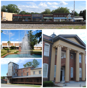
 Top, left to right: Downtown Central, Southern Wesleyan University, Central Roller Mills, Central High School | |
 Location of Central within South Carolina | |
| Coordinates: 34°43′26″N 82°46′47″W / 34.72389°N 82.77972°W | |
| Country | United States |
| State | South Carolina |
| County | Pickens |
| Incorporated | 1875[1] |
| Government | |
| • Mayor | Andrew J. Beckner[2] |
| Area | |
| • Total | 3.07 sq mi (7.94 km2) |
| • Land | 3.06 sq mi (7.93 km2) |
| • Water | 0.00 sq mi (0.01 km2) |
| Elevation | 906 ft (276 m) |
| Population | |
| • Total | 5,296 |
| • Density | 1,713.59/sq mi (661.56/km2) |
| Time zone | UTC−5 (Eastern (EST)) |
| • Summer (DST) | UTC−4 (EDT) |
| ZIP Code | 29630 |
| Area codes | 864, 821 |
| FIPS code | 45-13015[6] |
| GNIS feature ID | 1247236[4] |
| Website | cityofcentral.org |
Central is a town in Pickens County, South Carolina, United States. As of the 2010 census, the population was 5,159, roughly 3,000 of whom were considered permanent residents.[7] Contrary to its name, it is not near South Carolina's center. It received its name from being halfway or the central point between Atlanta and Charlotte along the former Atlanta and Richmond Air-Line Railway line. Southern Wesleyan University's main campus is east of downtown Central.
- ^ Cite error: The named reference
CHShistwas invoked but never defined (see the help page). - ^ Mayor's Corner Archived December 17, 2006, at the Wayback Machine from Central's official website
- ^ "ArcGIS REST Services Directory". United States Census Bureau. Retrieved October 15, 2022.
- ^ a b U.S. Geological Survey Geographic Names Information System: Central, South Carolina
- ^ Cite error: The named reference
USCensusDecennial2020CenPopScriptOnlywas invoked but never defined (see the help page). - ^ "U.S. Census website". United States Census Bureau. Retrieved January 31, 2008.
- ^ "Home | Town of Central". City of Central, SC.