- For the mountain in Argentina, see Cerro Catedral.
| Cerro Catedral | |
|---|---|
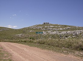
 The summit of Cerro Catedral, near a dirt road (Ruta 109). | |
| Highest point | |
| Elevation | 513.66 m (1,685.2 ft) |
| Prominence | 373 m (1,224 ft) |
| Listing | Country high point |
| Coordinates | 34°22′55.9″S 54°40′27.7″W / 34.382194°S 54.674361°W |
| Naming | |
| English translation | Cathedral Hill |
| Language of name | Spanish |
| Pronunciation | Spanish: [ˈsero kateˈðɾal] |
| Geography | |
| Location | Aiguá, Maldonado Department, Uruguay |
| Parent range | Sierra Carapé (part of Cuchilla Grande) |
| Geology | |
| Rock age | Precambrian |
| Mountain type(s) | Hill (granite, gneiss) |
| Climbing | |
| First ascent | Unknown |
| Easiest route | Hike |
Cerro Catedral ("Cathedral Hill"), also known as Cerro Cordillera, is a peak and the highest point of Uruguay, with an altitude of 513.66 m (1,685.2 ft). It is located north of Maldonado Department, in the municipality of Aiguá, in a hill range named Sierra Carapé, which constitutes part of a larger range named Cuchilla Grande. Its name derived from the curious forms of the rocky elevations of its summit, which are very common in the southern part of this country.
