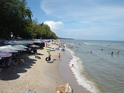
Cha-am
ชะอำ | |
|---|---|
 Cha-am Beach | |
 District location in Phetchaburi province | |
| Coordinates: 12°47′59″N 99°58′1″E / 12.79972°N 99.96694°E | |
| Country | Thailand |
| Province | Phetchaburi |
| Seat | Cha-am |
| Subdistricts | 9 |
| Area | |
| • Total | 660.65 km2 (255.08 sq mi) |
| Population (2021) | |
| • Total | 81,541 |
| • Density | 123.43/km2 (319.7/sq mi) |
| Time zone | UTC+7 (ICT) |
| Postal code | 76120 |
| Geocode | 7604 |
Cha-am[1] (Thai: ชะอำ, pronounced [tɕʰáʔām] or [tɕʰāʔām]) is a district (amphoe) in the southern part of Phetchaburi province, western Thailand.[2]
The district was established in 1897 with the name Na Yang. In 1914 the centre of the district was moved to Ban Nong Chok (now in Tha Yang district and its name was changed to Nong Chok. After World War II, the government moved the office to tambon Cha-am and also changed the district name to Cha-am.
Mrigadayavan Palace (Thai: พระราชนิเวศน์มฤคทายวัน, RTGS: Phra Ratchaniwet Maruekkhathayawan) in Cha-am district is a former residence of King Vajiravudh or Rama VI who ruled Siam from 1910 to 1925.
- ^ ประกาศราชบัณฑิตยสถาน เรื่อง การเขียนชื่อจังหวัด เขต อำเภอ และกิ่งอำเภอ (PDF). Royal Gazette (in Thai). 117 (พิเศษ 94 ง): 2. 14 Sep 2000. Archived from the original (PDF) on January 25, 2012.
- ^ "About Cha-am". Tourism Authority of Thailand (TAT). Archived from the original on 22 April 2019. Retrieved 26 December 2017.