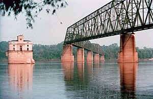
Chain of Rocks Bridge | |
|---|---|
 | |
| Coordinates | 38°45′38″N 90°10′35″W / 38.76056°N 90.17639°W |
| Carries | Pedestrians and bicycles (1998–present) |
| Crosses | Mississippi River |
| Locale | St. Louis, Missouri / Madison, Illinois |
| Maintained by | Trailnet |
| Characteristics | |
| Design | Cantilever through-truss |
| Total length | 5,353 feet (1,632 m) |
| Width | 24 feet (7 m) |
| Longest span | 700 feet (213 m) |
| History | |
| Opened | 1929 |
| Closed | 1970 (vehicle traffic) |
Chain of Rocks Bridge | |
| Location | West Chain of Rocks Rd., Madison, Illinois |
| Area | 12.6 acres (5.10 ha) |
| Built | 1929 |
| Architect | Brown, Baxter L.; et al. |
| Architectural style | Warren Truss |
| MPS | Route 66 through Illinois MPS |
| NRHP reference No. | 06001091[1] |
| Added to NRHP | December 1, 2006 |
| Location | |
 | |
The old Chain of Rocks Bridge spans the Mississippi River on the north edge of St. Louis, Missouri, United States. The eastern end of the bridge is on Chouteau Island (part of Madison, Illinois), while the western end is on the Missouri shoreline. Its most notable feature is a 22-degree bend occurring at the middle of the crossing, which was found to be necessary during construction due to both the presence of a water intake and the inability of parts of the bedrock of the river to carry the weight of the bridge.[2]
Originally a motor route, the bridge was for a time the route used by U.S. Route 66 (US 66) to cross over the Mississippi, but the bridge now carries only walking and biking trails over the river; the New Chain of Rocks Bridge carries vehicular traffic to the north.
The old route to the bridge is now called Chain of Rocks Road and ends near Roman Road. Parking is available at the start of the now-pedestrian route. The bridge was added to the National Register of Historic Places in 2006.[3]
- ^ "National Register Information System". National Register of Historic Places. National Park Service. March 13, 2009.
- ^ "Illinois: Chain of Rocks Bridge". National Park Service. June 7, 2022. Retrieved January 27, 2023.
- ^ "National Register of Historic Places Registration Form" (PDF). Missouri Department of Natural Resources. April 4, 2006. Retrieved January 17, 2010.[permanent dead link]

