Chalkyitsik
Jałgiitsik | |
|---|---|
| Motto: Vnm | |
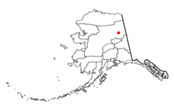
 Location of Chalkyitsik, Alaska | |
| Coordinates: 66°39′6″N 143°43′38″W / 66.65167°N 143.72722°W | |
| Country | United States |
| State | Alaska |
| Census Area | Yukon-Koyukuk |
| Government | |
| • State senator | Click Bishop (R) |
| • State rep. | Mike Cronk (R) |
| Area | |
| • Total | 8.76 sq mi (22.69 km2) |
| • Land | 8.50 sq mi (22.02 km2) |
| • Water | 0.26 sq mi (0.67 km2) |
| Population (2020) | |
| • Total | 56 |
| • Density | 6.59/sq mi (2.54/km2) |
| Time zone | UTC-9 (Alaska (AKST)) |
| • Summer (DST) | UTC-8 (AKDT) |
| ZIP code | 99788 |
| Area code | 907 |
| FIPS code | 02-11800 |
Chalkyitsik (/ˌtʃælkiˈɪtsɪk/ CHAL-key-IT-sick) (Jałgiitsik[pronunciation?][2] in Gwich'in), meaning "to fish with a hook, at the mouth of the creek", is a census-designated place (CDP) in Yukon-Koyukuk Census Area, Alaska, United States. It is located on the left (south) bank of the Black River, 45 miles northeast of Fort Yukon.[3] At the 2010 census the population was 69, down from 83 in 2000.
- ^ "2020 U.S. Gazetteer Files". United States Census Bureau. Retrieved October 29, 2021.
- ^ ANLC : Alaska Native Place Names
- ^ "GNIS Detail - Chalkyitsik".