Chambers County | |
|---|---|
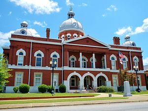
 Chambers County Courthouse in LaFayette, 2012 | |
 Location within the U.S. state of Alabama | |
 Alabama's location within the U.S. | |
| Coordinates: 32°54′40″N 85°23′38″W / 32.911111111111°N 85.393888888889°W | |
| Country | |
| State | |
| Founded | December 18, 1832 |
| Named for | Henry H. Chambers |
| Seat | LaFayette |
| Largest city | Valley |
| Area | |
| • Total | 603 sq mi (1,560 km2) |
| • Land | 597 sq mi (1,550 km2) |
| • Water | 6.6 sq mi (17 km2) 1.1% |
| Population (2020) | |
| • Total | 34,772 |
| • Estimate (2023) | 34,079 |
| • Density | 58/sq mi (22/km2) |
| Time zone | UTC−6 (Central) |
| • Summer (DST) | UTC−5 (CDT) |
| Congressional district | 3rd |
| Website | chamberscountyal.gov |
| |
Chambers County is a county located in the east central portion of the U.S. state of Alabama. As of the 2020 census the population was 34,772.[1] Its county seat is LaFayette. Its largest city is Valley. Its name is in honor of Henry H. Chambers,[2] who served as a United States Senator from Alabama.
Chambers County is included in the LaGrange, GA-AL Micropolitan Statistical Area and the Atlanta–Athens-Clarke–Sandy Springs Combined Statistical Area.[3]
- ^ "State & County QuickFacts". United States Census Bureau. Retrieved September 13, 2023.
- ^ Gannett, Henry (1905). The Origin of Certain Place Names in the United States. Govt. Print. Off. pp. 74.
- ^ https://www2.census.gov/geo/maps/metroarea/us_wall/Mar2020/CSA_WallMap_Mar2020.pdf [bare URL PDF]
