Chanhassen | |
|---|---|
 Barn in Chanhassen | |
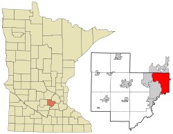
 Location of Chanhassen in Carver County, Minnesota | |
| Coordinates: 44°51′44″N 93°31′50″W / 44.86222°N 93.53056°W | |
| Country | United States |
| State | Minnesota |
| County | Carver, Hennepin |
| Settled | June 1852 |
| Organized | May 11, 1858 |
| Incorporated as a village | April 25, 1896 |
| Incorporated as a city | May 8, 1967 |
| Government | |
| • Mayor | Elise Ryan |
| Area | |
| • Total | 22.80 sq mi (59.06 km2) |
| • Land | 20.36 sq mi (52.73 km2) |
| • Water | 2.44 sq mi (6.33 km2) |
| Elevation | 974 ft (295 m) |
| Population | |
| • Total | 25,947 |
| • Estimate (2022)[3] | 26,224 |
| • Density | 1,274.35/sq mi (492.04/km2) |
| Time zone | UTC-6 (Central (CST)) |
| • Summer (DST) | UTC-5 (CDT) |
| ZIP code | 55317 |
| Area code | 952 |
| FIPS code | 27-10918 |
| GNIS feature ID | 2393799[4] |
| Website | chanhassenmn.gov |
Chanhassen (/ˈʃænhæsən/ SHAN-hass-ən)[5] is a city in Carver County, Minnesota about 16 miles (26 km) southwest of Minneapolis. A small portion extends into Hennepin County. [6] Located in the southwest Minneapolis–Saint Paul suburbs, there is a mix of suburban residential neighborhoods and rural landscapes. The population was 25,947 at the 2020 census, with a 2024 estimate of 26,469. [2]
- ^ "2020 U.S. Gazetteer Files". United States Census Bureau. Retrieved July 24, 2022.
- ^ a b "Explore Census Data". United States Census Bureau. Retrieved November 17, 2023.
- ^ Cite error: The named reference
USCensusEst2022was invoked but never defined (see the help page). - ^ U.S. Geological Survey Geographic Names Information System: Chanhassen, Minnesota
- ^ "Minnesota Pronunciation Guide". Associated Press. Archived from the original on July 22, 2011. Retrieved July 4, 2011.
- ^ "Community Classifications" (PDF). Met Council MN. Archived (PDF) from the original on November 30, 2021. Retrieved December 2, 2021.

