You can help expand this article with text translated from the corresponding article in French. (December 2008) Click [show] for important translation instructions.
|
Charente
| |
|---|---|
 Prefecture building of the Charente department, in Angoulême | |
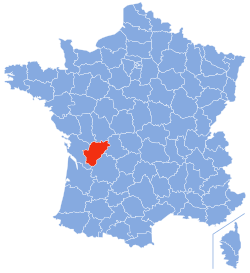
 Location of Charente in France | |
| Coordinates: 45°50′N 0°20′E / 45.833°N 0.333°E | |
| Country | France |
| Region | Nouvelle-Aquitaine |
| Prefecture | Angoulême |
| Subprefectures | Cognac Confolens |
| Government | |
| • President of the Departmental Council | Philippe Bouty[1] (DVG) |
| Area | |
| • Total | 5,956 km2 (2,300 sq mi) |
| Population (2021)[2] | |
| • Total | 350,867 |
| • Rank | 68th |
| • Density | 59/km2 (150/sq mi) |
| Time zone | UTC+1 (CET) |
| • Summer (DST) | UTC+2 (CEST) |
| Department number | 16 |
| Arrondissements | 3 |
| Cantons | 19 |
| Communes | 363 |
| ^1 French Land Register data, which exclude estuaries, and lakes, ponds, and glaciers larger than 1 km2 | |
Charente (French: [ʃaʁɑ̃t] ; Saintongese: Chérente; Occitan: Charanta [tʃaˈɾantɔ]) is a department in the administrative region of Nouvelle-Aquitaine, south western France. It is named after the river Charente, the most important and longest river in the department, and also the river beside which the department's two largest towns, Angoulême and Cognac, are sited. In 2019, it had a population of 352,015.[3]
- ^ "Répertoire national des élus: les conseillers départementaux". data.gouv.fr, Plateforme ouverte des données publiques françaises (in French). 4 May 2022.
- ^ "Téléchargement du fichier d'ensemble des populations légales en 2021" (in French). The National Institute of Statistics and Economic Studies. 28 December 2023.
- ^ Populations légales 2019: 16 Charente, INSEE

