This article includes a list of general references, but it lacks sufficient corresponding inline citations. (May 2011) |
Charles Village | |
|---|---|
 | |
| Country | United States |
| State | Maryland |
| City | Baltimore |
| Established | 1897 as Peabody Heights 1967 as Charles Village[1] |
| Population (2010) | |
| • Total | 8,267[2] |
| Demonym | Charles Villager |
| Time zone | UTC-5 (Eastern) |
| • Summer (DST) | EDT |
| ZIP code | 21218[3] |
| Area code | 410, 443, and 667 |
| Website | charlesvillage |
Charles Village-Abell Historic District | |
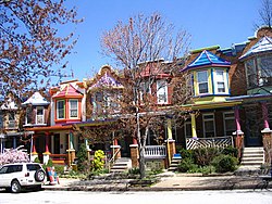
 Guilford Avenue rowhouses | |
 | |
| Location | Roughly bounded by University Parkway, Guilford Ave., and 25th, Mace, Charles, and Barclay Sts., Baltimore, Maryland |
| Coordinates | 39°19′27″N 76°36′55″W / 39.32417°N 76.61528°W |
| Area | 175 acres (71 ha) |
| Built | 1868 |
| Architect | Multiple |
| NRHP reference No. | 83003629[4] |
| Added to NRHP | December 15, 1983 |
Charles Village is a neighborhood located in the north-central area of Baltimore, Maryland, USA. It is a diverse, eclectic, international, largely middle-class area with many single-family homes that is in proximity to many of Baltimore's cultural amenities. Nearby are the Baltimore Museum of Art, the Homewood campus of The Johns Hopkins University, Olmstead's Wyman Park, the weekly Waverly Farmers Market, and the arts district, Station North. Homes are Baltimore brick and stone row houses, many dating from the 1890s.[citation needed] Running from downtown north is the historic boulevard, Charles Street, where Baltimore's Easter Promenade once took place.
The development of the neighborhood began in 1869 when 50 acres (200,000 m2) of land were purchased for development as "Peabody Heights." The land was divided and turned over to various builders who constructed home exteriors, leaving the interiors to be custom built according to buyer specifications. The area was first developed as a streetcar suburb in the early 20th century, and is thought to be the first community to employ tract housing tactics.[5] At the time, the area was known as Peabody Heights; the moniker Charles Village, derived from Charles Street, the area's major north–south corridor, was coined in the 1970s as the beginning of a process of conceptually grouping a large and somewhat heterogeneous area. The neighborhood history has been researched and published by Gregory J. Alexander and Paul K. Williams in their book Charles Village: A Brief History (The History Press, 2009).[6]
Charles Village in a strict sense consists of the area immediately to the east and south of the Johns Hopkins University Homewood campus. However, smaller neighborhoods to the east of this area — including Abell and Harwood, are considered by residents and other Baltimoreans to be part of Greater Charles Village. The Charles Village Community Benefits District (CVCBD) covers a hundred-block area generally bounded by 33rd Street to the north, Greenmount Avenue to the east, 25th Street (east of Guilford) and 20th Street (west of Guilford) to the south, and Johns Hopkins and Howard Street to the west. This area contains over 14,000 people and 700 businesses.[citation needed] The Charles Village Community Benefits District Management Authority (CVCBDMA) is a public entity that provides services within the CVCBD.[citation needed]
- ^ "Charles Village Civic Association, Baltimore, Maryland". Archived from the original on 2015-04-15. Retrieved 2015-04-15.
- ^ a b "Charles Village neighborhood in Baltimore, Maryland (MD), 21218 subdivision profile - real estate, apartments, condos, homes, community, population, jobs, income, streets". City-data.com. Retrieved 13 October 2017.
- ^ "Medfield neighborhood in Baltimore, Maryland (MD), 21211 subdivision profile - real estate, apartments, condos, homes, community, population, jobs, income, streets". City-data.com. Retrieved 13 October 2017.
- ^ "National Register Information System". National Register of Historic Places. National Park Service. July 9, 2010.
- ^ Tilghman, MK: Insiders' Guide to Baltimore, page 66. Insiders' Guide, 2008.
- ^ Fred B. Shoken (August 1983). "National Register of Historic Places Registration: Charles Village/Abell Historic District" (PDF). Maryland Historical Trust. Retrieved 2016-03-01.